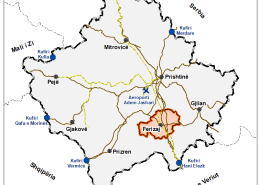
The municipality of Ferizaj covers an area of 345 km² and is situated in the southern part of Kosovo and in the north-eastern part of the Sharri mountains. In the east it is bordered by the Municipalities of Gjilan and Vitia; in the south by the Municipality of Kaçanik (16 km); in the southwest by Shtërpcë (32 km); in the west by Prizren (60 km) and Theranda (42 km); and in the north by Shtime (13km) and Lipjan (17km). The distance of Ferizaj from the capital of Kosovo, Prishtina, is 36 km and from Skopje is 48 km.
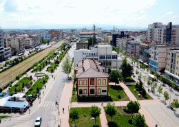
The city of Ferizaj occupies the central position in the territory of the municipality with an altitude of around 580 meters above sea level. Ferizaj is characterized by its favourable geographical position as it lies in the old Prizren-Anamorava and Prishtina-Skopje crossroads.
44.53% of the municipal area is plain, namely 10.98% in the south-west side, 4.03% in the east side, while the northern part is mainly on high ground around 5.78%, the northeast 7.96%, and in the north-west 6.71%. The city is situated around 580 meters above sea level and has a plain relief. The city relief enables a very good planning and development of the transport infrastructure. The largest river, Nerodime, crosses the entire territory of the municipality.
Ferizaj is characterized by a continental climate, like most of the Kosovo Plain. The average annual temperature is 10°C. The warmest months are July and August, with an average temperature of 18.9°C. The coldest month is January, with an average temperature of -2.6°C.


